Friday, November 30, 2012

Chapter 18: Transportation


On November 10, 2008, the City of San Fernando introduced the trolley as a new form of transportation for its residents. The trolley has two routes and twenty eight stops that help the residents move about the city. The trolley operates Monday thru Friday from 10:00am to 4:00pm, and on weekends it operates from 11:00am to 4:00pm. Customers usually wait for 15 minutes for the trolley and the fare is only twenty-five cents. You might also want to ride on the trolley just for fun, since it is only twenty-five cents. I did that with my kids. I gave them a quarter each, we hopped on the trolley, and we did a round trip. They really liked the experience.


Thursday, November 29, 2012

Chapter 16: Trees


Below are pictures of trees found  around San Fernando and in its surrounding mountains. Many of these trees provide shelter for many animals, and some provide food for many animals in the area.

These trees also create a beautiful landscape to see as you walk or drive by them.
 
Willows


Coast Live Oaks
 
 
California Sycamores


       Evergreen Oaks


Chapter 15:Earthquakes


Since San Fernando is located in the state of California, it is prone to earthquakes. San Fernando is located near the San Gabriel Fault.
 

On February 9, 1971, at 6:00 in the morning, San Fernando residents felt the earth shake. The epicenter of this earthquake was located about two miles away from San Fernando, in the city of Sylmar. It had a magnitude of 6.6, and it lasted about one minute. Many aftershocks were felt, including one with a magnitude of 5.


This earthquake claimed the lives of 65 people. It also damaged many buildings including two hospitals and schools. Two freeways were also greatly damaged. The total cost of the damage was estimated at about half a billion dollars.

Again on January 17, 1994, San Fernando was hit by another earthquake. This time the epicenter was located about 11 miles away in the city of Northridge. The magnitude for this earthquake was registered at 6.7, with two aftershocks at 6.0.

The Northridge earthquake claimed the lives of 57 people. The cost for the damages was much higher than the 1971 quake. The cost for the damages was estimated at $20 billions.


Chapter 14: Unemployment


In 1991, the population of San Fernando was 22,333. In 2011, there was an increase of about 6% bringing the population to 23,818.

The unemployment rate is San Fernando has increased from 5.4% in 2000 to 11.2% in 2012. The unemployment rate of San Fernando is slightly higher than that of California. In August of 2012, California had an unemployment rate of 10.4%.

According to the website area vibes, “The median household income in San Fernando is 21.5% less than the California average and 7.9% less than the National average. The poverty level in San Fernando is 41.2% greater than the California average and 55.4% greater than the National average.”


Sunday, November 18, 2012

Chapter 13: Wildlife


In this section I will mention some of the wildlife around San
Fernando. Much of San Fernando is highly developed, but in its
surrounding mountains, you can see certain types of wildlife
making this area their home. 

The two most common types of wild plants around San Fernando
are chaparral and sage scrub.

Many of the mountains surrounding San Fernando are home to
wild animals. Some of these wild animals are the coyotes, mule
deer, bobcats, raccoons, and skunks. Mountain lions can also be
found in the surrounding mountains. They are actually the top
predator in the area. In the Santa Susana and Santa Gabriel
Mountains, black bears make this area their home.


There are also 18 species of snakes and 8 species of lizards. You
can find pacific rattlesnakes (the only venomous snake in
California), gophers snake, California king snakes, and California
striped racers.


Saturday, November 17, 2012

Chapter 12: Native Indians


Many Native Indians of San Fernando were neophytes. To be a
neophyte, meant that these Native Indians had recently been
converted to the Catholic faith. In San Fernando, these Indians
were called Fernandinos. Many of these Indians suffered from
diseases that they were not immune to, and many passed away. In
1838-39, around 400 Indians lived in San Fernando, but theirs lives
were full of hardship because of corruption, and because they
were believed to be inferior to the new European settlers. Today,
the state of California refers to the Native Indians of San Fernando
as Tongva Indians.
 
 
Two Tongva Indians at the San Fernnado Mission          (http://www.scvhistory.com/scvhistory/jj1005.htm)


Chapter 11: Extreme Climate


Although the climate in the city of San Fernando is very Mediterranean, and the average rainfall is about 16 inches per year, once in a while the climate can get quite extreme. In 1997-1998, San Fernando, California experienced a period of time where there were plenty of storms day in, and day out, causing an excessive amount of rainfall compared to the amount rainfall from other years. This phenomenon is called El NiƱo. El NiƱo storms usually occur at the equator, but in the year 97-98, it reached San Fernando and other surrounding cities.
Since there was a lot of rainfall, there was also a lot of flooding and damage. Some vegetation, homes, and vehicles in the area were destroyed.
So what cause El NiƱo storms? “The trade winds have all the warm water pushed in the Western Pacific. During an El NiƱo year that warm water is in the Eastern Pacific, and so the storms coming into the West Coast of the United States and then on across the southern tier of the United States can tap into some of that warm, moist air that's above that water, and that adds to the effect and the strength of these storms.”

Below I have included a video that is a little bit less than an hour long, but it is a very interesting video that explains a little bit more about El NiƱo storms.


Monday, November 12, 2012

Chapter 10: Water in San Fernando


Where do residents of the City of San Fernando get their water
from?  The residents get their water from three different water
sources. The first source is “Local groundwater wells that draw
water from the Sylmar Basin.” Water is also imported from the
Metropolitan Water District. In extreme emergencies, water also
comes from a connection from the City of Los Angeles distribution
system. 98 percent of the water that was used in San Fernando in
2010, come from the local groundwater wells, and 2 percent was
purchased from the Metropolitan Water District.

To purify and treat the water, groundwater is taken from the Sylmar
Basin and chlorine is added in a sodium hypochlorite solution
(0.8%) used to disinfect the water. The process is monitored on a
daily basis. The water is then pumped into reservoirs, and thanks to
gravity it is distributed to homes and businesses in San Fernando.


http://www.ci.sanfernando.ca.us/city_government/departments/pubworks/forms_docs/water_quality_report_10_eng.pdf
http://www.wrsc.org/presentation/california-water-wars

http://www.ourventurablvd.com/May-June-2011/Under-Water/

Friday, October 12, 2012

Chapter 9: The Changing San Fernando


When the city of San Fernando was founded in 1797 by Father Fermin Lasuen, farming “was the most important industry,” just like the rest of the missions established in California.  The purpose of the Spanish missionaries was to teach the Indian men, who lived in this area, everything they needed to know about agriculture, and the care of livestock. In San Fernando, “Cattle ranching, sheep ranching, large-scale wheat farming, and fruit orchards flourished and faded” by 1915.  During the 1870’s and 1880’s, the wheat market was at its peak, but the “supply began to exceed demand, and prices began to fall.” Farmers began to sell their land and the real estate business began to boom. Roads were being constructed, and San Fernando was going from an agricultural land to an urban area.


Monday, October 8, 2012

Chapter 8: Topography


The City of San Fernando, as I have mentioned before, is located in the San Fernando Valley. San Fernando is a flat plain surrounded by several mountains. 

To the northwest, you will find the Santa Susana Mountains. The highest point in the Santa Susana Mountains is Oat Mountain with an elevation of 3.747 feet. The climate there is mild and dry during the summer, wet in the winter, and in high elevations snow can be seen.  The first discovery of oil in California happened in the north side of the Santa Susana Mountains at Naco Canyon.

To the west, you can see the Simi Hills. The highest point is at the Simi Peak with an elevation of 652m. Over 8,000 years ago, the Paleo-Indians and the Chumash-VenturaƱo Native Americans settled and hunted at the Simi Hills. There is rarely any snow here in the winter, the climate is mild, but rainy, and the summers are warm and dry.

To the south, are the Santa Monica Mountains with the highest peak being Sandstone Peak with an elevation of 3,111 feet.  The Chalk Hills are also to the south. Winters here are cool and wet with rarely any snow. The summers are dry, warm, and humid. There are over 1,000 archeological sites in the Santa Monica Mountains, mostly from the Tongra and Chumash Native American Cultures. The Chalk Hills are also to the south.  

To the east, are the Verdugo Mountains. This area is prone to wildfires. Verdugo Peak is the highest point with an elevation of 3,126 feet. The indigenous Tongva people made these mountains there home over 7,000 years old.

To the northeast, you can find the San Gabriel Mountains. The highest peak is at Mount San Antonio with an elevation of 10,068 feet. Snow covers these mountains in the winter time making snowboarding and snow skiing very popular. When the climate starts getting warmer, “Melting snow and rain runoff on the south side of the San Gabriel’s’ highest mountains give rise to its largest river, the San Gabriel River.


Friday, October 5, 2012

Chapter 7: Agriculture


If you were to visit the homes of the residents in San Fernando, chances are you will find a fruit tree in their front or back yard. The most popular fruit trees in San Fernando are citrus, apricot, apple, and avocado trees among many others.  The Mediterranean climate in this area seems to benefit the growth of these trees along with the water supplied through the San Fernando Valley aqueduct. The San Fernando Aqueduct was completed in 1913.

Since the city of San Fernando was first established, citrus trees have been a major part of this areas.  The cultivation of citrus trees was once the biggest industry in San Fernando.  During the early nineteen hundreds, “The price of land for orange and lemon groves went as high as $5,000 an acre, as much as eight times more than the cost of other land. The city had at least four packing houses with annual shipments of nearly 500 rail cars of oranges and lemons.”  The agriculture success of San Fernando, gave way to the growth and development of this cities.

 
If you are in San Fernando, and would like to visit a local farm, you can do so by visiting the Forneris Farm, where you can find many fresh fruits like strawberries, nectarines, peaches, honeydew melons, watermelons, plums, pears, and apples.


Chapter 5: Manufacturing


When San Fernando was established it was very much an agricultural city. Now, it has transformed into a more urbanized city. “Among the most common occupations in San Fernando are production, transportation, and material moving occupations, 24%; Sales and office occupations, 22%; Service occupations, 18%. Approximately 75 percent of workers in San Fernando, California work for companies, 11 percent work for the government and 6 percent are self-employed. The leading industries in San Fernando, California are Manufacturing, 20%; Educational, health and social services, 15%; and Construction, 9%.”

In the City of San Fernando there are a total of 7 manufacturing companies that handle clothing manufacturing. There are a total of six cities surrounding San Fernando that also deal with clothing manufacturing. In California, there are 300 that satisfy the publics need for clothing manufacturing.


Chapter 4: Urban Life


The city of San Fernando is an urban area that is only about 20 miles away from one of the world’s largest metropolitan areas. In 2010, it was estimated that Los Angeles was one of the most populated cities in the United States with a total population of 9,819,000 people. There have been large amounts of development in the region and urban sprawl.  Los Angeles is known as being part of a Megalopolis region meaning that it is a very large city.
 The following map shows where the biggest concentration of the population is located. It is easy to see that the coastal Southern region of California has the densest population. With the proximity of the City of San Fernando to the Megalopolis of southern California, it is easy for the residents of San Fernando to get caught up in life of a metropolitan area. This includes traffic, pollution, land changes, and high population density. Many residents of San Fernando look for work in the metropolitan area of Los Angeles and its surrounding cities.


Friday, September 14, 2012

Chapter 3: The Culture


The Hispanic or Latin culture is quite present in the city of San Fernando. This is due to the high percentage of people from Mexican or 
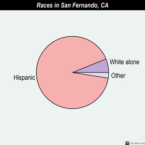
Latin American descent who reside in this city.  The following chart reflects that the majority of people living in San Fernando are Hispanics. The businesses, the music, the clothing, and the food around San Fernando truly reflect the Hispanic culture. You can find many Mexican food restaurants, quinceaƱera dress shops, Spanish songs playing in the local restaurants and stores, and clothing stores where you can purchase boots and sombreros. Due to the high percentage of Hispanics in San Fernando, it is almost certain that you will find Spanish speaking people in the local businesses, schools, and in many other public services locations.


•Hispanic - 21,867 (92.5%)

 •White alone - 1,259 (5.3%)

 •Asian alone - 192 (0.8%)

 •Black alone - 146 (0.6%)

 •American Indian alone - 66 (0.3%)

 •Two or more races - 82 (0.3%)

 •Native Hawaiian and Other Pacific Islander alone - 19 (0.08%)

 •Other race alone - 14 (0.06%)


In the city of San Fernando there are 10,225 residents are foreign born (42.7% Latin America).

This city:  43.4%

California:  26.2%

 A major part of the culture in San Fernando is also reflected by the religion that most residents practice. 69 % of the population belongs to the Catholic Church, 11% belong to the Evangelical denominations, 6% belong to the Mainline Protestant denominations, and 14% practice other faiths. Christmas, Easter, and December 12th Our Lady of Guadalupe Celebration are among the most popular holidays celebrated by many in the City San Fernando.  

Religion statistics for San Fernando:

 Percentage of population affiliated with a religious congregation:   58.08%

 San Fernando:  58.1%

USA:  50.2%


http://www.city-data.com/city/San-Fernando-California.html

Friday, September 7, 2012

Chapter 2: The Surrounding Mountains


The City of San Fernando is located in the San Fernando Valley. Therefore, it is surrounded by “the Santa Susana Mountains to the northwest, the Simi Hills to the west, the Santa Monica Mountains and Chalk Hills to the south, the Verdugo Mountains to the east, and the San Gabriel Mountains to the northeast.”
The land in the center of these mountains is flat with an elevation of about 600 ft. to 1,200 ft. above sea level and mostly urban.

One of San Fernando’s neighbor is the city of Sylmar. In Sylmar, CA, you can find a park named Veteran’s Memorial Park where you can go for a hike up a mountain trail and view from the top the City of San Fernando and its surroundings. I have done the hike twice, and below I have posted the view that you can see from the mountain top.


Here is a video I found on Youtube that shows the view from Veteran's Memorial Park.
 

Friday, August 31, 2012

Chapter 1: An Introduction to San Fernando


The city of San Fernando is located in the San Fernando Valley, in the northwestern region of Los Angeles County, California. The population of San Fernando was 23,645 at the 2010 census. The population increased since the census of 2,000, at this time the population was 23,564. The population density was 9,959.9 people per square mile (3,845.5/km²).


The city of San Fernando was named after the Mission San Fernando Rey de EspaƱa. In 1874 Charles Maclay, San Fernando founder, bought 56,000 acres (227 km2). The area of San Fernando today is 2.38 sq. miles (6.164 km²).


By the early 1800’s the city had blossomed into a small trading center where farm crop, olives, wine, and thousands of livestock raised by the resident Indians were bought and sold.

The average rainfall in San Fernando is about 16 inches per year, whereas the average in the United States is about 37 inches.  In July the average high is around 93 degrees and in January the average low is 43.


"City of San Fernando: For Visitors - About San Fernando." City of San Fernando: For Visitors - About San Fernando. N.p., n.d. Web. 31 Aug. 2012. http://www.ci.san-fernando.ca.us/for_visitors/about_sf/index.shtml.

http://www.city-data.com/city/San-Fernando-California.html